 Turn left at
the main road; the FP starts again on the right after about 100 yds on the left hand
bend in the road. The farm track to Micklehurst is met with after
a short trek over the meadow. After passing Kinder Barn the path
diverts right at a gate in the wire fence, but continues in the same direction. Passing over a series of styles, the
path descends into woodland, goes over the wooden bridge over the beck and ascends steeply to emerge by the side of
Lees House Farm. Keep right and follow the track to the road, turn left and
then right to the T-junction. A choice of return walks
to Whitewell is now available. (60 min)
Turn left at
the main road; the FP starts again on the right after about 100 yds on the left hand
bend in the road. The farm track to Micklehurst is met with after
a short trek over the meadow. After passing Kinder Barn the path
diverts right at a gate in the wire fence, but continues in the same direction. Passing over a series of styles, the
path descends into woodland, goes over the wooden bridge over the beck and ascends steeply to emerge by the side of
Lees House Farm. Keep right and follow the track to the road, turn left and
then right to the T-junction. A choice of return walks
to Whitewell is now available. (60 min) At the T-junction
find the gate on the left follow the path down to the stream and
then turn sharp left. The path becomes ill defined on approaching
the house. Keep to the left of the house and continue along the
track to Lower Lees. At the junction of the farm track turns right
to the farm and find the path 20 yds on the left. Follow the edge
of the field to a stile; keep to the high ground and follow the
path to the next stile which is adjacent to the road. Before the
stile turn sharp right, go downhill over a plank footbridge and
on to the Hodder. Follow the wire fence on the left over a series
of stiles and then a ford. The path now goes uphill and follows
the edge of Ing Wood and continues in a straight line to the road.
Turn left at the road; the path continues a few yards further on
at a metal gate on the left. From here the path through sheep
pasture back to Whitewell is well defined. (90 min)
At the T-junction
find the gate on the left follow the path down to the stream and
then turn sharp left. The path becomes ill defined on approaching
the house. Keep to the left of the house and continue along the
track to Lower Lees. At the junction of the farm track turns right
to the farm and find the path 20 yds on the left. Follow the edge
of the field to a stile; keep to the high ground and follow the
path to the next stile which is adjacent to the road. Before the
stile turn sharp right, go downhill over a plank footbridge and
on to the Hodder. Follow the wire fence on the left over a series
of stiles and then a ford. The path now goes uphill and follows
the edge of Ing Wood and continues in a straight line to the road.
Turn left at the road; the path continues a few yards further on
at a metal gate on the left. From here the path through sheep
pasture back to Whitewell is well defined. (90 min) A circular
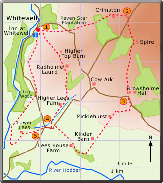
walk from Whitewell
Warning: In winter time Stages 1 and 2 could prove a little taxing because of the wet ground.
 At the road
turn right and take the FP immediately left; walk uphill go over
the style and head for the chimneys of Spire. At Spire the path follows
the extreme edge of the wood. After passing Spire bear slightly left and
head for the break in the band of trees seen in the distance ahead. On reaching the end of the wood on the left look for the stile on the left. Turn right after the stile and over the next stile (pond on the left). The path is now almost
a straight line (due south) downhill over sheep pasture to the farm track leading
to Browsholme Farm. (45 min)
At the road
turn right and take the FP immediately left; walk uphill go over
the style and head for the chimneys of Spire. At Spire the path follows
the extreme edge of the wood. After passing Spire bear slightly left and
head for the break in the band of trees seen in the distance ahead. On reaching the end of the wood on the left look for the stile on the left. Turn right after the stile and over the next stile (pond on the left). The path is now almost
a straight line (due south) downhill over sheep pasture to the farm track leading
to Browsholme Farm. (45 min)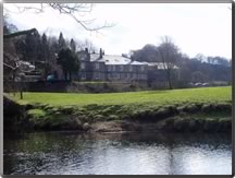
The
Inn at Whitewell as seen from the Hodder bank
The present Inn at Whitewell was in former times the Manor. In medieval
times it acted as the Court House where Forest tenants and Forest keepers
met to decide local issues. In more recent times a market used to be held
in the forecourt of the house. The Inn is now a hotel and popular meeting
place for drinks and meals.
"Forest" from the Old French "foris" meaning land for hunting game was first declared such by the Norman, Robert de Lacy. Red and fallow deer were hunted in the Forest where Radholme Laund was a deer enclosure.
The park keepers of old became the Parkers now of Browsholme Hall.
As well as the local history, the present walk takes in some spectacular scenery and the enjoyable Inn at Whitewell.