Walking
the Hodder - Stage 3
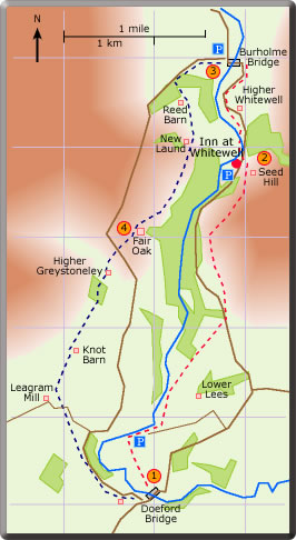
Doeford Bridge to Burholme Bridge
Distance 7.84 miles : time about 3 hours 45 min
<Stage 2  Stage
3 Stage 4 >
Stage
3 Stage 4 >
![]() The
FP starts at the bridge. Walk uphill following the waymarkers to
the top left hand corner of the field. Follow the old hedge on
the left, go through the double gate. The hedge on the right leads
down to the Hodder. Turn right at the farm track and walk along
the road for 300 yd to the stile. Bear left (walk due N) across
the field to meet the Hodder again. The walk following the Hodder
crosses a stile and a ford and then heads uphill towards the wood
(aim for the large dead tree). After the stile follow the wood
on the left and carry straight on to the stile at the roadside
at the top end of the wood ahead. Turn left at the road and then
right through the metal gate. The path initially follows the road
but then after the first old metal gate gently climbs to follow
the escarpment. After the second such gate go through the double
gate on the left and follow the track to Whitewell. At the cottage
on Seed Hill turn left and walk down to the road. (60 min)
The
FP starts at the bridge. Walk uphill following the waymarkers to
the top left hand corner of the field. Follow the old hedge on
the left, go through the double gate. The hedge on the right leads
down to the Hodder. Turn right at the farm track and walk along
the road for 300 yd to the stile. Bear left (walk due N) across
the field to meet the Hodder again. The walk following the Hodder
crosses a stile and a ford and then heads uphill towards the wood
(aim for the large dead tree). After the stile follow the wood
on the left and carry straight on to the stile at the roadside
at the top end of the wood ahead. Turn left at the road and then
right through the metal gate. The path initially follows the road
but then after the first old metal gate gently climbs to follow
the escarpment. After the second such gate go through the double
gate on the left and follow the track to Whitewell. At the cottage
on Seed Hill turn left and walk down to the road. (60 min)
![]() After
the Inn at Whitewell find the FP behind the stone wall on the
left; this leads to a concessionary path through sheep pasture
which avoids walking on a particularly narrow stretch of road.
Thereafter continue along the road to Burholme Bridge. (15 min)
After
the Inn at Whitewell find the FP behind the stone wall on the
left; this leads to a concessionary path through sheep pasture
which avoids walking on a particularly narrow stretch of road.
Thereafter continue along the road to Burholme Bridge. (15 min)
![]() Walk
along the road to the wood on the left. The entrance to Reed
Barn/New Laund Farm is seen after 300 yd. The farm road passes
Reed Barn and continues to the farm complex. Just before the
farmhouse and after the barking dogs turn right up the hillside.
Carry straight on to the stile at the double gate. A well-defined
old grassy track leads to a beautiful view of the wooded Hodder
valley. The path now descends to a ladder stile over the stone
wall and continues following waymarkers to join the track to
Fair Oak. (45 min)
Walk
along the road to the wood on the left. The entrance to Reed
Barn/New Laund Farm is seen after 300 yd. The farm road passes
Reed Barn and continues to the farm complex. Just before the
farmhouse and after the barking dogs turn right up the hillside.
Carry straight on to the stile at the double gate. A well-defined
old grassy track leads to a beautiful view of the wooded Hodder
valley. The path now descends to a ladder stile over the stone
wall and continues following waymarkers to join the track to
Fair Oak. (45 min)
![]() Turn
left at the first house and then right and left through the farm
complex. Walk across the field (bearing 250’) to find two
stiles at the top right-hand corner of the field. The path crosses
the road and carries on across the field to the stile which lead
on to the track just before Higher Greystoneley. The grassy track
leads to a lovely woodland walk, fords the beck, carries on past
Knot Barn and ends at the road close to Leagram Mill. Cross the
stile over the road and follow the hedge on the right to the
stile at the top right-hand corner of the field. Turn right at
the road for Loud Mytham and then left at the T-junction for
Doeford Bridge. (55 min)
Turn
left at the first house and then right and left through the farm
complex. Walk across the field (bearing 250’) to find two
stiles at the top right-hand corner of the field. The path crosses
the road and carries on across the field to the stile which lead
on to the track just before Higher Greystoneley. The grassy track
leads to a lovely woodland walk, fords the beck, carries on past
Knot Barn and ends at the road close to Leagram Mill. Cross the
stile over the road and follow the hedge on the right to the
stile at the top right-hand corner of the field. Turn right at
the road for Loud Mytham and then left at the T-junction for
Doeford Bridge. (55 min)
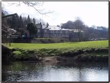
The Inn lies on the banks of the River Hodder and is set in the beautiful wooded
surroundings of the Hodder gorge.
It is a very popular meeting place for drinks and meals.
See the website for opening times.